- Subsea cables form the essential infrastructure for global internet connectivity, carrying about 99% of international data traffic across oceans and continents.
- Subsea cable maps provide valuable insights into the economic and geopolitical dynamics of global connectivity, highlighting key routes, data hubs, and potential vulnerabilities.
- The future of subsea cables is being shaped by advancements in fiber optic technology, new cable routes, sustainability efforts, and emerging technologies like quantum communication.
We often take for granted the seamless experience of accessing information, communicating across continents, and streaming high-definition content. This digital convenience is largely made possible by an unseen yet critical infrastructure: subsea cables. These underwater giants form the backbone of the global internet, stretching across oceans and seas to connect continents and carry the bulk of international data traffic. To truly appreciate and understand the complexity and significance of this network, we turn to subsea cable maps. These maps not only illustrate the physical paths of data flow but also provide insights into the technological and geopolitical aspects of global connectivity.
The backbone of global connectivity
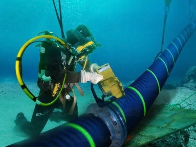
Subsea cables, also known as submarine or undersea cables, are fiber optic cables laid on the ocean floor, connecting land-based stations across continents. These cables are responsible for transmitting the vast majority of data traffic between countries, with estimates suggesting they handle around 99% of international communications. Despite the rise of satellite technology, subsea cables remain the preferred method for data transmission due to their higher capacity, lower latency, and greater reliability.
Each cable consists of multiple fiber optic strands, each capable of transmitting terabits of data per second. These strands are encased in protective layers to withstand the harsh conditions of the deep sea, including pressure, temperature variations, and potential damage from anchors or natural events.
Also read: ITW 2024: BW Digital and Telin sign MoU for subsea cable
The importance of subsea cable maps
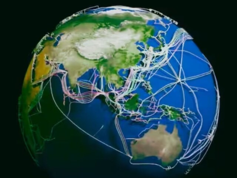
Subsea cable maps serve as graphical representations of the global network of undersea cables. They provide a visual overview of how continents are interconnected and highlight key hubs and routes in the global internet infrastructure. These maps are valuable for several reasons:
Visualisation of connectivity
Subsea cable maps help us visualise the intricate network that enables global communication. By seeing the physical routes data takes, we gain a better understanding of how information flows between different parts of the world.
Identifying vulnerabilities
Understanding the layout of subsea cables allows us to identify potential points of failure in the network. For instance, if a significant portion of data traffic passes through a single cable or region, that point becomes a critical vulnerability. Natural disasters, geopolitical tensions, or technical failures in these areas could disrupt global connectivity.
Infrastructure planning
Telecommunications companies and governments use subsea cable maps for planning new cable routes and enhancing existing networks. This planning is crucial for improving internet speed, reliability, and capacity. By analysing current routes and identifying underserved regions, stakeholders can make informed decisions about where to invest in new infrastructure.
Economic and strategic insights
Subsea cable maps provide insights into the economic and geopolitical dynamics of global connectivity. Countries with extensive subsea cable infrastructure often enjoy strategic advantages in terms of data flow and connectivity. These maps reveal how digital power is distributed globally and highlight the importance of certain regions as data hubs.
Notable subsea cable maps
Several organisations and companies create and maintain detailed subsea cable maps. These maps vary in terms of detail, interactivity, and the scope of information provided. Here are a few notable examples:
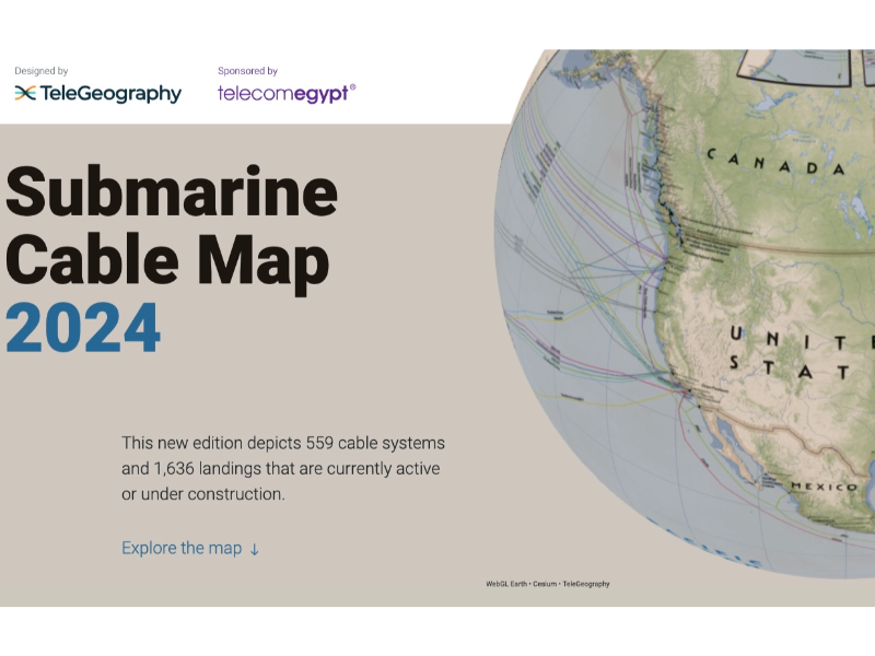
TeleGeography’s Submarine Cable Map
One of the most comprehensive and widely used resources, TeleGeography’s Submarine Cable Map is an interactive tool that provides up-to-date information on existing and planned cables, landing points, and more. The map is user-friendly and allows users to explore different layers of data, such as cable ownership and network capacity.
Greg’s Cable Map
This open-source project offers a detailed, interactive map of subsea cables. It is a popular resource for both enthusiasts and professionals, providing information on cable routes, landing stations, and technical specifications. The map is regularly updated and allows users to visualise the global cable network in various ways.
SubmarineCableMap.com
This site offers a comprehensive overview of submarine cables, including detailed maps, technical specifications, and historical data. It is a valuable resource for those looking to understand the evolution of subsea cable infrastructure and its current state.
Also read: Google is investing $1 billion in subsea cables connected to Japan
The evolution of subsea cables
The history of subsea cables dates back to the mid-19th century when the first transatlantic telegraph cable was laid between Ireland and Newfoundland in 1858. This early cable allowed for telegraphic communication across the Atlantic, revolutionising long-distance communication. However, it was fraught with technical challenges and had a short lifespan.
The development of more durable and efficient cables in the subsequent decades led to the establishment of a global telegraph network. The advent of telephone technology in the early 20th century further expanded the subsea cable network, allowing for voice communication across continents.
The most significant transformation came with the introduction of fiber optic technology in the late 20th century. Fiber optic cables, which use light to transmit data, offered vastly greater capacity and speed compared to traditional copper cables. This innovation paved the way for the modern internet and the explosive growth of global connectivity.
Current state of the subsea cable network
Today, the global subsea cable network spans over 1.2 million kilometers, connecting every continent except Antarctica. This network consists of hundreds of cables, ranging from a few hundred kilometers to over 20,000 kilometers in length. Some of the most important cables include the Atlantic Crossing (AC) series, the Pacific Light Cable Network (PLCN), and the SEA-ME-WE series, which connect Southeast Asia, the Middle East, and Western Europe.
The subsea cable industry is a dynamic and rapidly evolving field. New cables are constantly being planned and deployed to meet the growing demand for data transmission. For example, the Dunant cable, a Google project, connects Virginia Beach, USA, to Saint-Hilaire-de-Riez, France, and offers a capacity of 250 terabits per second, making it one of the highest-capacity cables in the world.
Challenges and vulnerabilities
While subsea cables are critical for global connectivity, they are not without challenges and vulnerabilities. Some of the key issues include:
Physical damage
Subsea cables are susceptible to physical damage from various sources, including fishing activities, ship anchors, and natural events like earthquakes and underwater landslides. Repairing damaged cables is a complex and costly process that can take weeks to complete.
Geopolitical tensions
Subsea cables often traverse international waters and touch multiple countries, making them subject to geopolitical tensions. Disputes over territorial waters, regulatory differences, and security concerns can impact the deployment and maintenance of cables.
Environmental impact
The laying of subsea cables can have environmental impacts, particularly in sensitive marine ecosystems. Efforts are made to minimise these impacts through careful planning and the use of environmentally friendly technologies, but challenges remain.
Security threats
Subsea cables are vulnerable to security threats, including espionage and sabotage. Governments and companies invest heavily in securing these cables and monitoring their integrity to protect against such threats.
Subsea cable maps provide a fascinating glimpse into the hidden network that powers our digital world. These maps help us understand the complexity and significance of global connectivity, highlighting the routes and hubs that enable the seamless flow of data across continents. As technology advances and the demand for data continues to grow, subsea cables will remain a vital component of our interconnected future.