?")
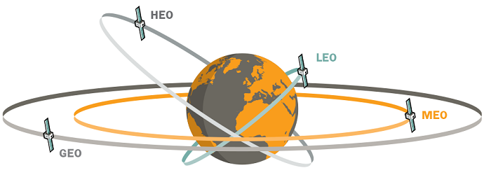
- Medium earth orbit refers to a specific region in space situated between Low Earth Orbit (LEO) and Geostationary Orbit (GEO).
- MEO satellites occupy an altitude range typically between 2,000 to 36,000 kilometres (1,243 to 22,300 miles) above the Earth’s surface.
- MEO satellites are commonly known for their significant role in global navigation systems, with the most prominent example being the Global Positioning System (GPS).
A medium earth orbit (MEO) satellite orbits the earth at an altitude above that of a low earth orbit (LEO) satellite and below that of a geostationary earth orbit (GEO) satellite. MEO, which is sometimes also called intermediate circular orbit (Ico), provides a vast range of options to those deploying satellites and strikes a balance between the costs of higher altitude constellations and the coverage of low orbit satellites. MEO satellites operate at altitudes between 1,000 miles and 22,000 miles and orbit the earth at least twice a day. Some have perfectly circular orbits while others track elliptically, but all track the same orbit continuously once it has been established.
Also read: How does space weather affect satellites?
MEO definition
Medium Earth Orbit (MEO) refers to the region in space between Low Earth Orbit (LEO) and Geostationary Orbit (GEO), typically ranging from 2,000 to 36,000 kilometers (1,243 to 22,300 miles) above Earth’s surface.
MEO satellites are essential for global navigation systems, such as the Global Positioning System (GPS). These satellites form a constellation that ensures global coverage, providing precise positioning, navigation, and timing services. By transmitting signals with exact timing information, GPS receivers on the ground can triangulate their position, velocity, and time with high accuracy, thanks to the multiple MEO satellites visible from any location on Earth.
It takes less energy to keep satellites on course in MEO because there’s minimal gravitational pull from the Earth as well as less atmospheric drag.
“Station-keeping is easier in MEO versus LEO and requires less fuel,” notes Gregory Henning, a project leader who specialises in space debris simulations with the Aerospace Corporation.
In addition to lower fuel consumption, one of the main advantages of MEO is that satellites have a higher vantage point compared to LEO and this means it takes fewer satellites to provide full coverage of the Earth. This makes MEO ideal for navigation satellites. It is home to the U.S.’s Global Positioning Satellite System, as well as Galileo, GLONASS and BeiDou, the European, Russian and Chinese versions of GPS.
“If you were to try to do the GPS mission in LEO, the number of satellites you would need would be enormous,” says Henning. Compared to the thousands of satellites in LEO, MEO contains under 200 satellites.
“The trade-off is, the further away from Earth that you go, the stronger your transmit power beam needs to be; thus, the larger your equipment and the bigger your satellite, so it (generally) costs more to launch (satellites into MEO compared to LEO),” notes Kerstyn Auman, a space situational awareness (SSA) analyst at the Aerospace Corporation.
Another trade-off that’s wholly unique to MEO involves the two zones of energy charged particles above the equator known as the Van Allen radiation belts. Satellites passing through these belts must have special shielding to avoid damage to their electronic systems.
Along with LEO, MEO is the target destination for a new missile warning, missile tracking and missile defense program under development at Space Systems Command. It will supplement the existing SBIRS (Space-Based Infrared) satellites in geosynchronous orbit and provide an overlapping layer of resiliency to the nation’s space sensing capabilities.
Also read: Elon Musk introduces Starlink satellite internet service in Indonesia
How did MEO satellites come about?
They are not a new concept in the satellite world. The first communications satellite, Telstar, which was launched in 1962 was a medium earth orbit satellite designed to facilitate high-speed telephone signals. Following its launch, it rapidly became apparent that having a single MEO satellite in space was inadequate because it only provided transatlantic telephone signals for 20 minutes of each of its approximately 2.5-hour orbits. The concept of satellite constellations composed of multiple MEO satellites was born.
What are the advantages of MEO satellites?
MEO satellites strike a balance between the characteristics of LEO and GEO satellites. LEO satellites, which typically orbit around the equator in a circular pattern, require about two dozen units to ensure continuous coverage.
MEO satellites orbit at higher altitudes, offering greater coverage. With 24 MEO satellites, four can cover any given spot on Earth at any time, helping service providers avoid communication outages due to weather or obstructions. LEO satellites, however, have the advantage of providing clearer surveillance images and needing less power for data transmission.
GEO satellites operate at much higher altitudes, providing extensive coverage. They orbit Earth in 24 hours, appearing fixed relative to the Earth, ideal for consistent communication relays. In theory, three GEO satellites, spaced 120 degrees apart, could offer continuous global coverage. However, the limited orbital positions for satellites using the same radio frequency pose risks of interference or collision.
Additionally, placing a satellite into GEO orbit, which is 22,300 miles (35,800 km) high, requires a large rocket and significant onboard fuel. Satellites typically reach this orbit indirectly by first entering a geosynchronous transfer orbit, then firing rockets at a precise time to boost to the desired altitude.
MEO satellites offer a compromise between the benefits and drawbacks of LEO and GEO satellites. Although MEO satellites have longer orbits than LEO, they still appear to move from an Earth-based observer’s perspective. A constellation of MEO satellites requires fewer units than LEO but more than GEO, balancing construction and deployment costs. Their lower altitude compared to GEO also reduces latency.
Moreover, MEO satellites can capture weaker signals at lower altitudes than GEO satellites. Their transmitter power and antenna size offer a middle ground between the modest requirements of LEO and the substantial needs of GEO.
What are the applications of MEO satellites?
Aside from defence industry applications, MEO satellites are ideally suited to deployment for communications purposes. They are most frequently used in GPS tracking and mobile telephone communications although their successful deployment is making them more frequently discussed as a potential solution for the expanding needs of asynchronous transfer mode (ATM) and other broadband communications networks.
Navigation systems remain the most common use of MEO satellites. Current deployments include the Global Positioning System and Russia’s Glonass. A proposed MEO navigation for the European Union called Galileo is expected to begin operations in 2013.